Kielce Radom Special Interest Group Collaboration
Intro | The Journal | Areas of Inclusion | Maps | Town List
Serving researchers with an interest in towns and villages that were located in the former Kielce and Radom Gubernias of Russian Poland
After many years of providing outstanding contributions to in-depth research of this area of Poland, the Kielce-Radom Special Interest Group Journal ceased publication in 2004. During that time, the indices published in the Journal to many of the towns were transferred to Jewish Records Indexing – Poland and became available in the JRI-Poland online searchable database.
Since 2004, the full extracts for tens of thousands of records from most towns, originally published in the K-R Journal, have been integrated into the JRI-Poland database and are freely available and searchable online. Over time, extracts from all towns will be added. In addition, searchable PDF copies are now available online. See “Contents of the K-R SIG Journal” below.
Kielce-Radom Special Interest Group Journal
History of the Journal
The Kielce-Radom Special Interest Group was formed in 1997 under the direction of an Advisory Group comprising Warren Blatt, Lauren Davis and Gene Starn. The goal of the founders was to promote cooperative research of the Jewish population of Kielce and Radom gubernias (regions in southern Russian Poland). Warren Blatt was the founding editor and Gene Starn founding Coordinator. Mark Froimowitz subsequently joined as Coordinator in 2000. The Advisory Group was composed of Warren Blatt (Editor), Debra Braverman (Membership) and Carol Isaak (Production) beginning in 2002.
The SIG produced a quarterly publication, the Kielce-Radom SIG Journal, from 1997 to 2004. The Journal published articles applicable to research throughout Russian Poland, as well as research projects such as index extractions/transliterations from LDS microfilms of vital records.
Intro | The Journal | Areas of Inclusion | Maps | Town List
Areas of Inclusion
Intro | The Journal | Areas of Inclusion | Maps | Town List
Maps
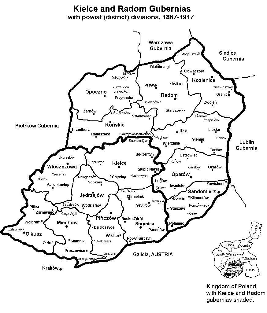
Outline map of Kielce and Radom Gubernias, with districts, 1867 - 1917 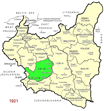
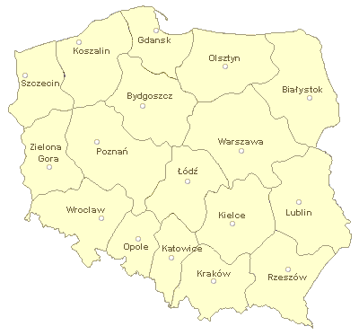
Provinces 1919 - 1939: Kielce province 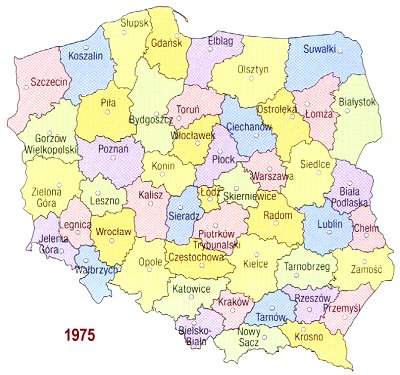
Provinces 1975 - 1998: Kielce province, Radom province 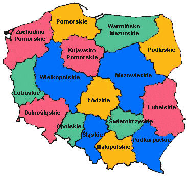
Provinces 1999 - today: Swietokrzyskie, Mazowiecki, Malopolski, Lodz, Slask
Intro | The Journal | Areas of Inclusion | Maps | Town List
Towns in Kielce and Radom Gubernias
Intro | The Journal | Areas of Inclusion | Maps | Town List
Explanation of Column Headings
Town — Name of the town, in the current Polish spelling.
Yiddish Town Name — Name of the town, in Yiddish, compiled by Warren Blatt and Perets Mett.
Pronunciation Notes:
- Most Yiddish words have the stress on the first syllable. Most Polish words stress the penultimate (next-to-last) syllable.
- Exception to note #1: Town names ending in -in are usually stressed on the last syllable, e.g.: Khen-tshin' (Chęciny), Shteko-tshin' (Szczekociny), Zvo-lin' (Zwoleń), Ben-din' (Będzin), Lub-lin' (Lublin).
- Polish Yiddish frequently de-voices 'v', so that e.g. Stashev is actually pronounced Stashef.
District — Name of the district (Polish powiat) that the town was in, during the 1867-1917 period. Source: Atlas geograficzny illustrowany Krolestwa Polskiego, edited by J. M. Bazewicz (Warszawa: [1907]). For an outline map of the district borders, click here.
1897 Jewish Population — Jewish population in 1897, according to the All-Empire Census, as cited in Еврейскяя Энциклопедія Evreiskaia Entsiklopediia [Jewish Encyclopedia] (St. Petersburg: Brokhaus-Efron, 1906-1913). Articles on "Kielce Gubernia" (Vol. IX, cols. 949-951) and "Radom Gubernia" (Vol. XIII, cols. 268-271) contain population statistics for all towns with a Jewish population of over 500. Articles for each of the 14 powiats (districts) contain population statistics for all towns with a total population of 500 or more.
1897 Percent Jewish — Percentage of the town that was Jewish in 1897, calculated from the population tables in Evreiskaia Entsiklopediia.
1931 Jewish Population — Jewish population in 1931, according to the second national census of Poland of 1931. These figures are taken from Black Book of Localities Whose Jewish Population was Exterminated by the Nazis (Jerusalem: Yad Vashem, 1965); which in turn are taken from Drugi powszechny spis ludności z dnia 9 grudnia 1931 r. (Warszawa: Główny Urząd Statystyczny, 1934-1938).
Latitude / Longitude — The town's latitude and longitude. Positions are taken from the JewishGen ShtetlSeeker which is based upon the U.S. Board on Geographic Names (BGN) database: Gazetteer of Poland. 2nd edition (Washington: Defense Mapping Agency, 1988).
FHL microfilms — Years for which Jewish vital records (births, marriages and deaths) have been microfilmed by the Genealogical Society of Utah (the microfilming arm of the LDS Family History Library). Source: Family History Library Catalog™ (FHLC), 1996 microfiche edition; and corrections based on personal knowledge. See the FHLC Locality section under the headings "POLAND, [Province], [Town] - JEWISH RECORDS" for details and microfilm ordering numbers.
Provinces: The FHLC uses Poland's 1945-1975 provincial borders. Most of the old Kielce and Radom gubernias (1867-1917) are covered by the 1945-1975 province of Kielce. However, the borders do not overlap exactly, and some areas are covered by neighboring provinces: Kraków province in the southwest (parts of old Olkusz and Miechów districts); Katowice province (part of old Olkusz district); and Lublin province in the northeast (part of old Kozienice district).
The notation "RC" indicates that there are civil transcripts of Roman Catholic vital records listed in the FHLC for the 1810-1825 period. It is during this period that the Roman Catholic civil transcripts included Jewish registrations. Separate records were kept by each religious community beginning in 1826. See the InfoFile Jewish Vital Records in Poland for more information.
There were thousands of other smaller villages in the Kielce-Radom region, which are not listed here. Their vital records are included amongst those of a neighboring larger town. To determine the location of a village, you can consult the JewishGen ShtetlSeeker or the U.S. Board on Geographic Names database, available as Gazetteer of Central and Eastern Europe on microfiche from Avotaynu, Inc.
Intro | The Journal | Areas of Inclusion | Maps | Town List