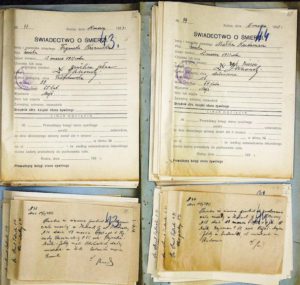
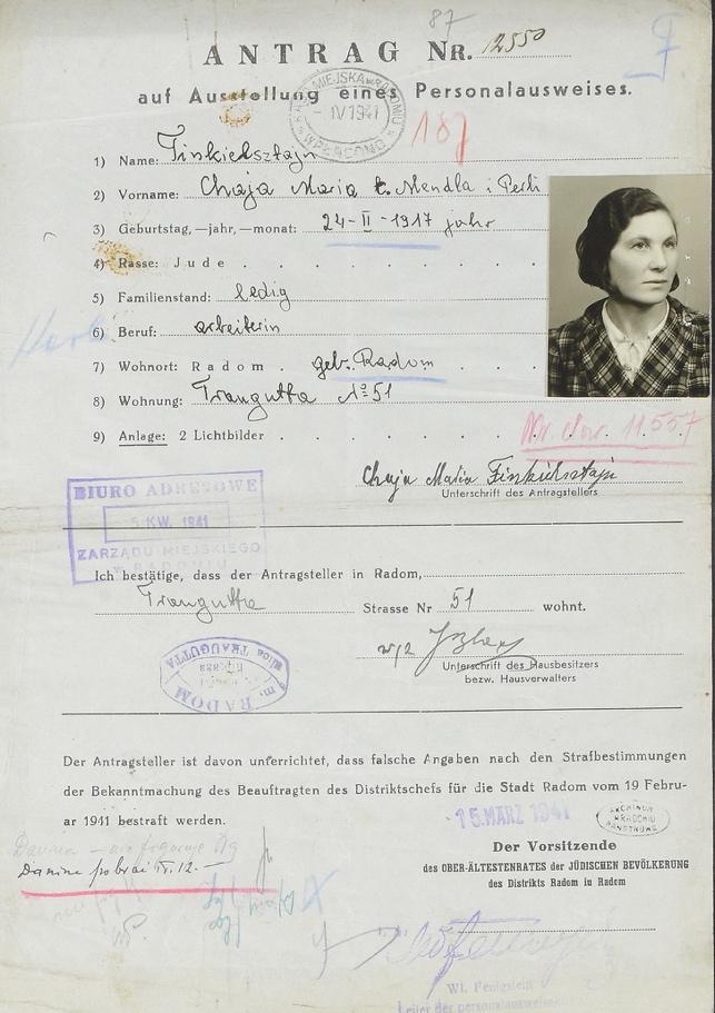
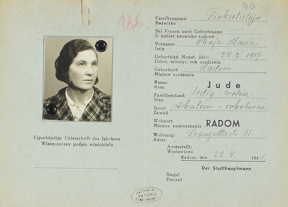
1941 Radom Ghetto ID Cards and ID Card Applications
Contributed by Judy Golan (Israel) and Luke Rothman (Washington, D.C.)
The Radom branch of the Polish State Archives has digitized their holding of 1941 Radom Ghetto ID Cards and ID Card Applications [58/387/0/-/SIGS 1-143] and made them available online.
While prior years’ cards were in Polish, these are in German. The thoughtful Archive management translated and displayed the text into Polish for each individual. Unlike the earlier cards for use in the normal day-to-day activities of Polish citizens, the Ghetto cards were part of the system for controlling the Jewish population at the time of war.
These documents – of 14,076 Jews residing in the Radom Ghetto in 1941 – are now searchable on the JRI-Poland database, including direct links to the images of 1,136 ID cards and 14,040 ID Card Applications for a total of 15,176 links to document scans.
Making this collection an even more invaluable treasure is that nearly 75% of the documents have photos – either on the application or the ID Card or both. For many families, these may be the only surviving photographs of their family members who resided in Radom, the vast majority of whom died in Treblinka in August 1942.
While we included the original record translations provided by the PSA, to facilitate search on the JRI-Poland Legacy Database we have parsed out the information and made an extensive, concerted effort to correct clerical errors in the vital data associated with each individual. The entries include:
- name
- date or year-of-birth
- town of birth
- civil status
- sex
- parentage
- occupation
- street address
Parents’ given names were converted to the nominative form, so that, for example, “Moskego i Chawy Laji” appears as the more familiar “Moszek and Chawa Laja.” When names were unclear or illogical in the translations, we checked the application scans. In several cases no parentage was listed on the record, yet the translation stated parents’ names. This surely came from Radom vital records. To validate ambiguous names and dates, we cross-checked the data against registrations found in the metric extract file of the birth town.
The applicants were split almost equally among men and women; the oldest person in the data file was a widow born in 1850 – age 91; the youngest was age 12, with the average age about 38. The Under-21 group represented 16% of these individuals. Of those applicants where civil status was indicated, about 54.5% were married and 5.8% were widowed.
While 57% of the individuals whose records indicated town of origin were born in Radom, more than 700 other towns are listed as town-of-birth. With some exceptions, the majority of these towns/villages are in the Radom Gubernia or vicinity, with the top five represented by Przytyk, Warszawa, Zwoleń, Szydłowiec and Iłża. In the Spring of 1941, Jews were transported into Radom from Przytyk and other towns, so this likely skewed the numbers.
Where it was obvious, spelling of the town names was standardized. Some town names cannot be found on Google Maps; for others, Google Maps displays the correct modern town name. For example, “Bereza Kartuska” points to Biaroza, Brest Region, Belarus, while both “Dyneburg” and “Dźwińsk” show Daugavpils, Latvia.
Unlike the town names, street names were changed if appropriate. When the Polish State Archives transcribed the documents in collection 58/387/0, they generally used the 1939 street names, which can be found on this map.
During the German occupation (1939-1945), many streets in Radom were renamed; after the war ended, some reverted to their old names, while some were given new names. Many street names were also changed during the Communist Era (1947-1989), and many have been changed again since that time.
The 14,076 individuals in this database lived at nearly 1,200 different addresses on 118 different streets in Radom. Because the PSA transcriptions don’t always match the street names on the scans, and since some street names have been changed multiple times or have existed in different locations at different times, JRI-Poland has standardized the addresses in this database in order to match current locations as closely as possible. Twenty-three street names have been expanded in the JRI transcription (for example, Struga is now Andrzeja Struga), and sixteen streets have been updated to the current name per the table below:
| Street name on card | Current street name |
| 1 Maja | 25 Czerwca |
| Bekermanów | Parkowa |
| Daleka | 11 Listopada |
| Dolna | Tadeusza Mazowieckiego |
| Gieryczewska | Dąbrowskiego Henryka |
| Głowackiego | Szarych Szeregów |
| Mleczna | Generała Leopolda Okulickiego [note: there is a current, unrelated street called Mleczna] |
| Pereca | Podwalna |
| Pierackiego | Mieczysława Niedziałkowskiego |
| Plac Legionów | Rynek |
| Podjazdowa | ul. Beliny-Prażmowskiego Władysława |
| Staro-krakowska | Krakowska [note: the current Starokrakowska is in a different location] |
| Targowa | Bolesława Chrobrego |
| Wronia | Harcmistrza Kapitana Eugeniusza Stasieckiego |
| Żabia | Wiktora Cymerysa-Kwiatkowskiego |
| Zatylna | Mordechaja Anielewicza [note: only part of the former Zatylna street still exists today] |
The 1939 map and the Ghetto map are a researcher’s best reference for the street name changes. This website also has a useful list of name changes.
The vital data provided in these cards offers a cross-check and validation of the vital data found in the Radom metric records and the Radom Book of Permanent Residents.
For additional information on Radom resources and extracts, please contact us via the JRI-Poland Town Explorer page: https://www.jri-poland.org/town/radom/
Project Team – 1941 Radom Ghetto ID Cards and ID Card Applications
- Judy Golan, JRI-Poland Kielce-Radom-Sandomierz Area Coordinator
- Luke Rothman, Researcher
- Michael Tobias, OBE, Legacy Database Manager
Historical Background and Context
According to Krzysztof Urbański’s “Zagłada Żydów w dystrykcie radomskim” (“The Holocaust of Jews in the Radom district”), a Generalgouvernement decree on November 23, 1939, required that, as of December 1, 1939, all Jews would be required to wear a white armband with a Star of David on the right sleeve. In December, additional decrees restricted the movement of Jews, and required colored patches on their armbands to indicate skills that could be utilized for forced labor.
Through 1940, many additional decrees led to the impoverishment of the Jewish community. Jewish hospitals, homes for the elderly, and orphanages lost all tax benefits; ration cards for Jews were half the amount given to Poles (who, in turn, received far less than Germans); military veterans lost their pensions; commerce was severely restricted; farms and businesses were confiscated; forced labor was implemented on a large scale.
Urbański writes, “The expansion of the occupation administration and the combined confiscation of the best apartments meant that the housing situation systematically deteriorated.” The ID cards and applications in this collection convey a sense of normalcy, but by early 1941, the situation was already dire for the majority of Radom’s Jewish residents.
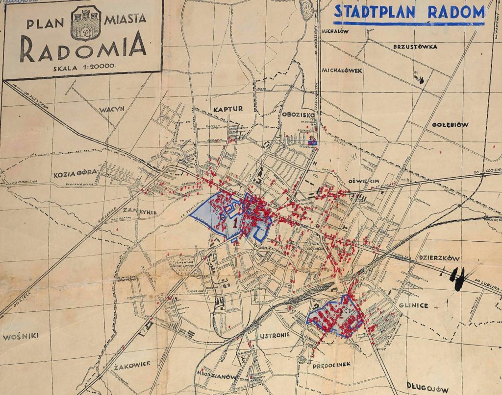
In February 1941, the Radom Judenrat announced that Jewish adults were required to apply for identity cards during the month of March. Applicants were told to pick up their identity cards from late March through late April 1941 (we noted that most ID card applications were indeed date-stamped mid-March 1941). On April 3, this announcement established two geschlossenen jüdischen Wohnbezirken (“closed Jewish residential districts,” commonly referred to as ghettos). All non-Jews in those areas were required to vacate their apartments by April 10, and all Jews were required to relocate to the ghettos by April 12. This map (courtesy of POLIN Museum of the History of Polish Jews) shows the borders of the “large ghetto,” situated in the center of the city, and the “small ghetto,” located in the area surrounded by the suburbs of Ustronie, Prędocinek and Glinice.
Pins representing the approximately 1,200 unique addresses found on the ID card applications were added to the map below by geocoding the street addresses and georeferencing the original map. This visualization provides some insight as to the scope of the April 3 decree: all Jews living outside of the blue boxes on the map were given nine days to vacate their homes and move to the ghetto. It is presumed that after April 12 no Jews were openly living at any of the addresses outside of the ghettos.
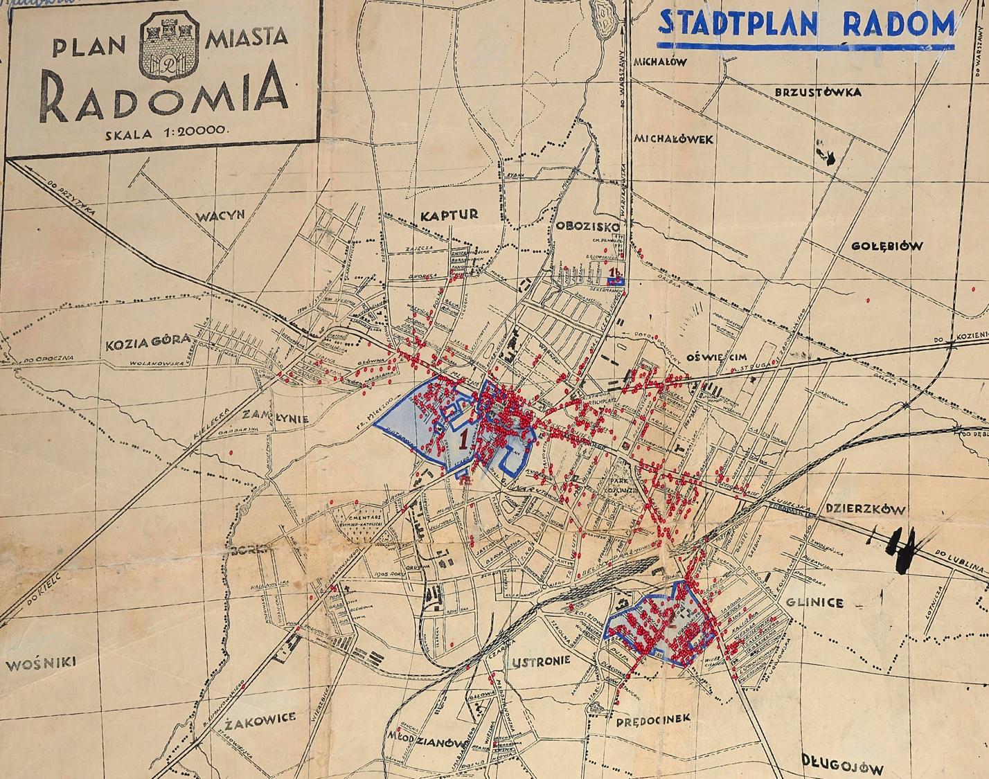
1941 map of Radom with the Ghettos and pins showing where Jews resided between February-April 1941 (Map in Public Domain, courtesy of POLIN Museum, pinpoints by Luke Rothman, used with permission)
Further information on the ultimate fate of the inhabitants of the two ghettos can be found in this article (in Polish) by the Radom historian Sebastian Piątkowski, who describes the liquidation of the “small ghetto” on August 4-5, 1942, and the liquidation of the “large ghetto” on August 17-18, 1942. In the span of two weeks, nearly thirty thousand Jews were sent from Radom to Treblinka.